I knew that the new section of cycleway started at the
Central Station end of Waterloo Street at the junction with Hope Street,
presumably with the train/ bike commuter in mind. I did not join it exactly at
this point, having come in along the Victoria Road shared lane with buses and
taxis which is practically deserted on a Sunday morning.

At the Clutha pub I turned left and joined the recently
refurbished section of the Clyde walkway opposite Calton Place heading west and
passing maybe half a dozen people cycling the opposite way towards Glasgow
Green and to...well who knows, the velodrome or just along the walkway for a
social ride perhaps.
While nothing to do with the Connect2 project, the walkway
is now looking rather good, and certainly at this early hour was quiet and free
of winos and rowdy kids. The one thing I have heard consistently over the years
about travel by bicycle is that it has the ability to put you in the moment; you
definitely do appreciate much more of your surroundings on a bicycle than when stuck
in a car.

Negotiating the deceptively low bridge passing under the
road I emerged unexpectedly onto some cobbles that led me to a choice of
continuing over and back onto the walkway, or to rejoin the road parallel. I chose the road and a few moments later made a right and
left turn which led me to the cycleway in Waterloo Street.

On a deserted Sunday morning devoid of delivery lorries and
white van man it was possible to get a proper look at this piece of
engineering. The temptation with anything like this is to simply say thank you
kind sirs and meekly go on with daily life, but having ridden a bicycle for the
sole purpose of getting around in
Amstelveen and Haarlem in Holland, I could not help but wonder if the person
who came up with the design had ever seen let alone studied the segregated bike
paths in Holland? I did not have a tape
measure, but it did not feel wide enough to accommodate a great volume of two
way traffic. Maybe I’m just being picky, I moved off and noticed immediately the
drain covers and curiously positioned bollards in the lanes.

Two things spring to mind here, firstly the bollards are
black, maybe I’m being picky again but perhaps white with some reflective
stripes would have been better, but wait, why are they even there? Surely they
would be better spaced along the separating strip next to the double yellow
lines to reinforce the idea of the
lane being segregated. Anyway I’m nitpicking again, within a few minutes I had
reached the end of the segregated cycleway and landed on a short section of
shared use path. The main carriageway carries straight on to the M8 at this
point while pedestrians and cyclists cross together at traffic lights and head
up the ramp onto the bridge over the M8 motorway. There is no photograph of the
crossing as it was completely blocked by a road maintenance lorry.

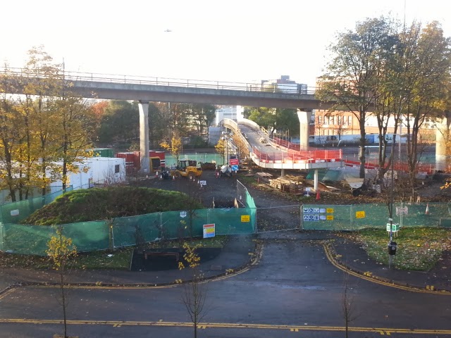
The bridge is a superb construction, sweeping over the
multiple lanes of traffic beneath and providing fast, safe access to the
Anderston/ Woodside borderlands. Underfoot or underwheel the surface feels
quite secure even on a damp morning like this was, it was absolutely fine,
hopefully this will still the case in icy conditions.

Intriguingly there exists another partially completed bridge
at the other end of which I know absolutely nothing except it appears to be
actively under construction and would provide a link from the new bridge over
to the south side of the clydeside expressway, a nasty 50 mph A-road,
effectively an urban motorway, that no right minded cyclist would venture on
to.
The drop down from the bridge is not too steep but care had
to be taken at the very bottom due to the slippery carpet of leaves, a seasonal
hazard. A little to the left of the bridge exit was a path that seemed to be
used by pedestrians and cyclists alike, this led to a wide pavement that
eventually stopped at the Skypark technology building and then...well that is
really it.

The so-called bridge to nowhere, a nickname I have never
heard used by anyone bar the media, is in itself a fine construction but
ultimately, and hopefully only temporarily, is now a bridge to nowhere of much
consequence. What would be nice would be for the west exit to connect up to
some high quality, traffic calmed paths that would lead into the west end
proper. I am hoping that this is part of a greater plan to connect the city centre
to the west end for pedestrians and cyclists. We can but hope...or campaign in
earnest.